
Catastrophic. Deadly. Monstrous. Historic. Biblical.
All these descriptors terrifyingly embody the desolation brought to Western North Carolina and the greater east coast by Hurricane Helene. However, no word is more apt in chronicling North Carolina’s most devastating storm to date than one.
Unprecedented.
That’s the exact word Corey Davis, an assistant state climatologist at the North Carolina State Climate Office, used when describing the cataclysm and its impact across the western part of the state.
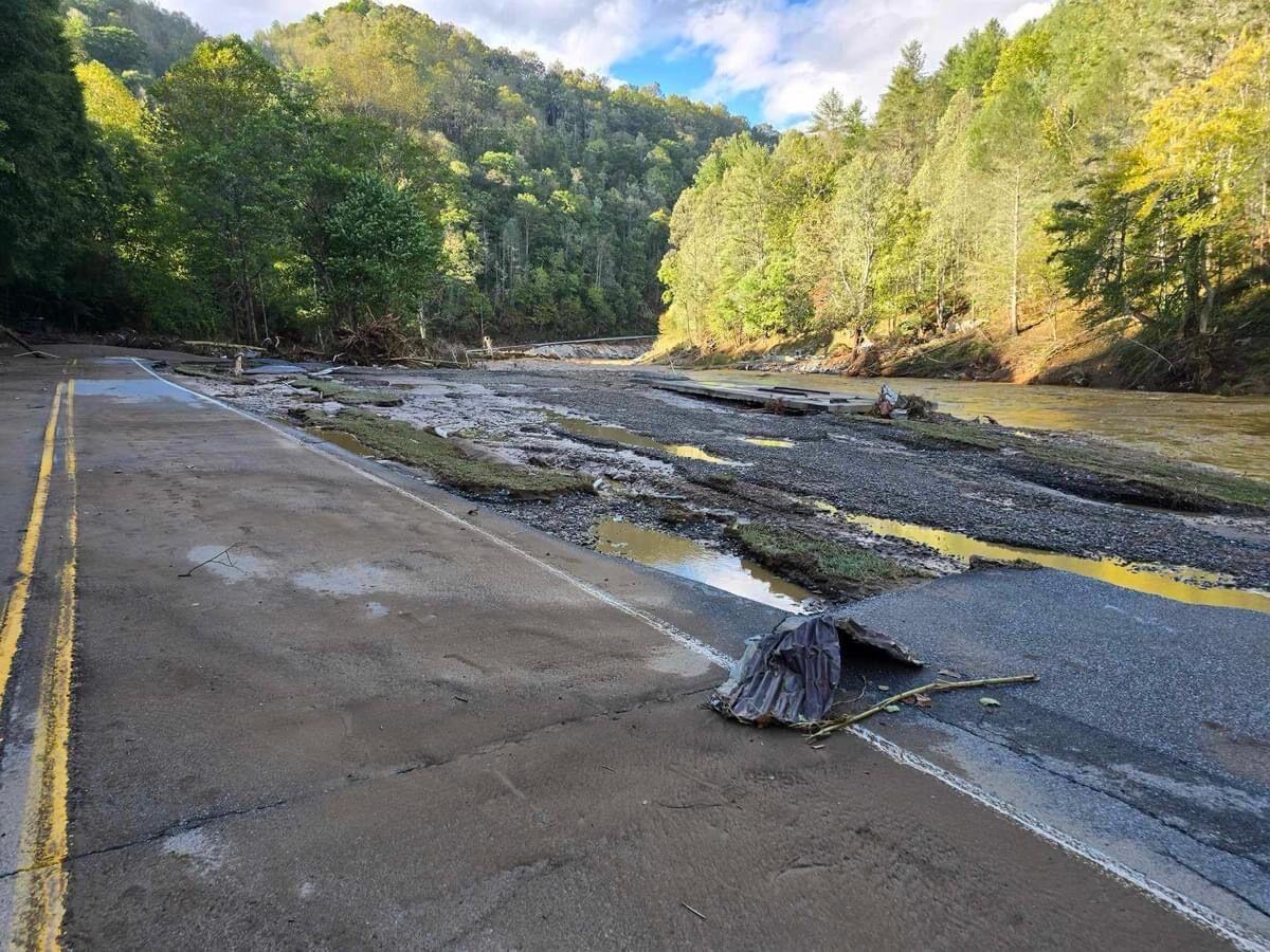
The scale of the disaster was unparalleled. The death toll under Helene has nearly reached 250, with reports of people still unaccounted for weeks after the storm. Additionally, the storm caused damages that eclipsed $50 billion. It shut down countless roads, erased entire towns and displaced thousands of people across the region.
The storm marked a wake-up call for those in the area, which was especially susceptible to Helene and future storms because of its location in the Appalachian Mountain range. However, experts said there are ways to better inform those living in the region’s high-risk areas and ways to adapt to climate change’s exponential impact on future storms.
The makings of catastrophe in Western NC
An NC State meteorology graduate, Davis recounted past storms in the Appalachian region surrounding Asheville — the epicenter of Helene’s damage in NC — and said Helene was nothing like those that had come before.
While the Asheville area is no stranger to storms and flooding and the damage that accompanies them, Davis said a stalling cold front over the region that preceded Helene’s true rain bands primed the area for historic flooding. The storm brought eight to 10 inches of rain before even making landfall in the Florida panhandle.
“So at that point we’re realizing, especially once those rainfall totals come in, this is at or above the levels of those historical storms,” Davis said. “It didn’t take long before you saw pictures and videos come out from these areas and realize that the level of flooding they were going through was just a step beyond anything they ever had in the past.”
By the end of the storm, Davis said rainfall totals were upwards of 30 inches in some areas, much more than anything it had historically experienced. Davis said the totals were triple that of the next biggest storm in the region’s history.
“In the Asheville area, they had 14 inches of rain in three days, and that’s worse than a one in 1,000 year type event — the type of event that only has a one in 1,000 chance of happening in any given year. Now, they’re probably not that rare in reality. But still, this is beyond the totals they had seen.”
The biblical amounts of rain contributed to extreme runoff in surrounding areas, which were home to a majority of Western North Carolina’s population.
Georgina Sanchez, a research scholar and faculty fellow at the Center for Geospatial Analytics at NC State, said her research has demonstrated that built environments in steep topography areas tend to congregate near streams and, therefore, on and around floodplains.
“That water then ran into the streams and the rivers in the mountains — they were full,” Davis said. “So when you started getting that extra rain from the hurricane on top of that existing moisture, it just had nowhere to go. It spilled over from the rivers into the towns and cities around there.”
When Helene’s rainfall combined with the already-saturated soils in the region, devastating landslides and flooding occurred. Both phenomena had significantly worse impacts on these high-risk, floodplain-adjacent developments that are located at the bottom of high-topography areas.
“That, in my mind, was a build up towards a perfect storm that led to so much damage and devastation,” Sanchez said. “A lot of people are surprised by the fact that this happened. I don’t think we should be this surprised.”
Lack of awareness and protection against storms
Both Davis and Sanchez shared the sentiment that it was hard for people in the area to understand the severity of the incoming storm due to a lack of awareness around the dangers of living in these high-risk areas. Sanchez said not a lot of people were aware that this was, and still is, a high-risk location.
Sanchez said the greatest concentrations of built environment both in the region and nationwide are located an average of 250 meters from the edge of floodplains, which equates to just two city blocks. It’s a trend that puts more people and buildings at risk.
“You walk that in a minute and a half,” Sanchez said. “That’s a very narrow chunk of land where we’re aggregating most of our overall resources, our infrastructure, our population.”
Sanchez says it is a misconception that these areas are safe and that risk extends beyond the designated floodplain borders in which development is most common and even encouraged.
Additionally, Sanchez said buildings in FEMA-designated high-risk areas are federally required to have flood insurance, among other flood-prevention strategies. However, she said this policy has had unintended consequences.
“It ended up facilitating or sort of opening a door for so many potential buyers, homeowners, business owners, to say, ‘Well, if the government is providing federally supported insurance and legislation, let me go ahead and build into this location because then there is a mechanism that would help me out, in case a flood-event were to strike,’” Sanchez said. “Rather than, ‘Let’s avoid building there, because floodplains flood and we may not want to build there.’”
Sanchez also said this rule only applies to those with federally backed mortgages, leaving true property owners without the requirement to buy insurance, meaning many simply do not. Sanchez said this contributed to the immense amount of people in the area that suffered uninsured damage. In fact, only 5% of Helene victims had insurance, resulting in $100 to $200 billion in uninsured damages.
Sanchez said even those outside designated floodplain areas are still at risk due to a combination of variability in conditions, the magnification of storms and currently outdated data that exclude future projections of the effects of climate change.
“A lot of those floodplain maps are generated using historical flood events or historical climate information rather than current or future,” Sanchez said. “So effectively, a lot of them are built to characterize risk of the past, not really the present, much less the future. FEMA is not currently including any type of climate change consideration when generating flood plain maps. … Climate change is not incorporated.”
Climate change’s continued impact on future storms
Davis said storms such as Helene — and their resulting fallouts — will only continue to increase in severity over time, suggesting the need for consideration of these effects on floodplain risk data and mapping.
Climate change is set to primarily intensify all future storms that occur — a difference from the common misconception that the frequency of storms, specifically hurricanes, will increase. Davis cited the 2020 North Carolina Climate Science Report’s findings on the subject were in line with the severity of Helene and Hurricane Milton, which caused $34 billion in damages and at least 24 deaths after it made landfall near Tampa, Florida.
“In that report, it mentions that the strongest storms are expected to keep getting stronger, and certainly that rapid intensification that gets them [to a severe level] is expected to become more common,” Davis said. “We’ve seen that twice now in the past month with Helene and Milton also, because the atmosphere overall is warming. A warmer atmosphere generally tends to be wetter. It can support more moisture, more precipitation so that these storms, when they do hit, are dropping more rainfall than they did in the past.”
Davis compared hurricane formation to following a recipe for a cake. Certain combinations of the right ingredients blend to create a deadly product. Rather than butter, eggs and sugar, Davis said hurricanes are fueled by warm ocean temperatures, humid atmospheric conditions and clusters of strong thunderstorms — all of which are increasing and intensifying due to climate change.
“So if the ocean temperatures are warmer, that means that these storms can get stronger and get stronger faster,” Davis said. “If the atmosphere is overall more humid and there’s less dry air around these storms, then that means they’re less likely to weaken and more likely to stay strong, and like we saw Helene, grow to a really big size.”
These changing conditions and strengthening of ingredients lead to storms like Helene. More importantly, these trends won’t stop, meaning storms of Helene’s unprecedented magnitude will become the new normal.
“Because of what we see with Helene, with its size, its strength, and I think because of those connections with a warming and changing climate, I think we can point to that storm and say this is the type of event that is possible with climate change,” Davis said.
Davis said storms comparable to Helene are likely to be the new normal in the future. Until, of course, the next unprecedented storm of even greater force hits.
It’s a vicious cycle, one that has been in motion for hundreds of years already. Davis said throughout the United States’ history of hurricanes, the events have only scaled in magnitude, becoming deadlier and redefining our image of the worst case scenario with each and every landfall.
“These storms are not going to go away,” Davis said. “If anything, they’re going to get stronger and more frequent in terms of the big impacts that we see here in the state, but also that there’s really nowhere in the state that’s going to be safe from these storms and their impacts as they reach us with stronger wind speeds, with more moisture intact. That means more areas are going to see the sorts of damage that we’ve seen from storms like Matthew and Florence and Helene over the next 50, 60 years.”
Adapting to the effects of climate change
Sanchez said there is going to be a continuing trend of developing in high-risk areas. With climate change in mind, she says the danger for those in areas such as Western North Carolina could increase.
In order to combat, or more aptly adapt to these changing conditions, Sanchez said better communication surrounding the effects of storms and specifically the risk of flooding is needed.
“Is there a way to reach out to that community, with a campaign of: Find out your actual risk and use modeling that would help them understand at any given year and based on current, climate observations and future projections, what is your real actual risk?” Sanchez said. “Rather than, what is your risk that was once estimated on a climate that no longer exists? I think that would be really important as a first step, so that people can take action.”
Sanchez said people should think in terms of action-oriented 30-year time frames when evaluating key decisions such as buying a house, opening a business or investing in flood insurance if near a high-risk area.
While individuals can take their own steps to prepare for the ever-growing effects of hurricanes spurred on by climate change, Sanchez said local authorities and long-range urban planners should plan for the future as well.
“Are we planning to continue to grow in areas that we know may experience flooding in the future?” Sanchez said. “Can we relocate potential growth to a safer location? All of that is really important to consider. In my mind, there lies a really positive future [that can be] action-oriented, solution-oriented, supported-in-science, that hopefully will keep people safe.”